
|
Icy lagoons in iceland
Vik, Iceland |
Another day, another adventure!
This time off around the southern coast of Iceland. All the way over to the largest glacier – Vatnajökull.
On the north edge of this glacier is the Bardarbunga volcano. This is the volcano which had been threatening to erupt for almost the last week. Yesterday the volcano warning was upgraded to red.
I’m not going on a tour today. Rather joining a friend who I met in Central America and we are driving around!
She picked me up at 7.30am. The streets in the city were full of litter from last night! We headed out of the city and into the countryside. It’s a long drive around to the glacier – just over 400km.
We got a tad lost whilst trying to leave the city and ended up going the wrong way…google maps soon put us straight.
More beautiful landscapes. Volcanos, rocky areas, coast, farm land, small villages, moss, lakes. All so pretty. After winding around a small mountain surrounded by black volcanic sand, we went through a small geothermal town, the ground was steaming. Here they are famous for having health centres and green houses for growing produce. The green houses were all lit up.
Our first stop was the Seljalandsfoss waterfall.

This was a 60m tall cliff and a narrow stream of powerful water flowing over the edge. Behind, was a small cavern which had been eroded away by all the water. It was so pretty. Seagulls floating around. Moss growing all around the cavern.
It is possible to walk all around the cavern, so that you are behind the waterfall. I got rather wet! Was cool though! Back on the road again.
Our second stop was the next waterfall – Skógafoss waterfall. This one was much larger – being 25m across, a more traditional sheet of water. At the base was a shallow river running away from it on a large flat rocky ground. There were hundreds of steps leading up the cliff side to reach the top of the waterfall – a bit of exercise!!

From the top you could see all around the surrounding farm land, cows, sheep and small little farm houses. A while later we made a coastal stop – just outside the town of Vik. Here there is a black sand beach and rocky coastal cliffs. We walked/climbed around some of the rocky cliff area. Was cool!
Basalt columns, slate-like ground and sea stacks. And the long stretching, completely black sand.

Vik is a very, very small town. There was a church, petrol station and not much else! But seemed to be quite a busy tourist stop off! From Vik it was then a 2 hour drive to reach our main destination – the glacier lagoon.
About half an hour outside of Vik, we spotted the glacier. It looked like a big icy mountain. And didn’t look all that far away.
We kept driving and driving and it didn’t seem to be getting any closer!
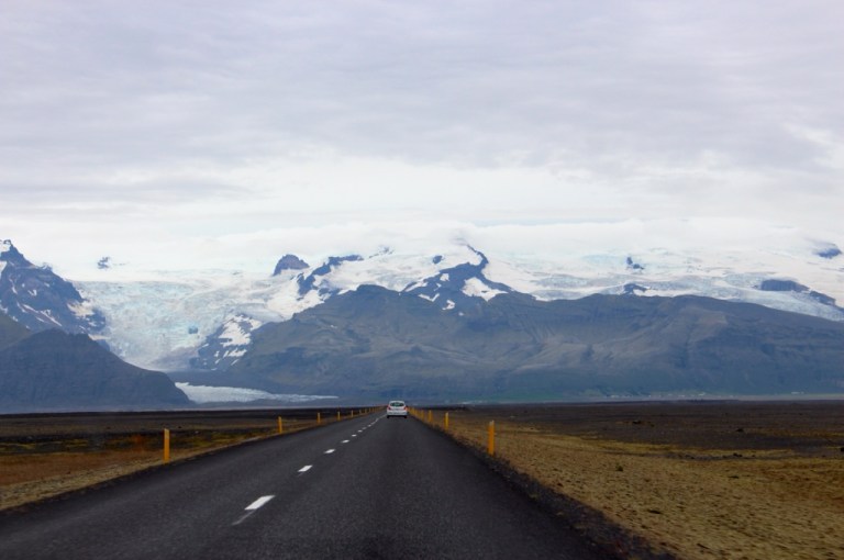
Eventually we reached it and saw several sections of glacier – some bits were almost fluffy. Others looked like solid blocks of ice.
And then finally at 2pm, we arrived at the glacier lagoon!
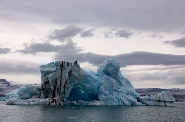
Jökulsárlón is the best known and the largest the glacial lakes in Iceland. It is at the southern end of the Vatnajökull glacier and is 18 km². The deepest part reaches over 200m deep. It was so amazing. So pretty. I’ve never seen anything like it!!
Clear blue water with floating lumps of ice – white, black and blue. So many colours.
Hundreds of seagulls. And even seals playing around in the 2 degree water. The black glacier ice is from volcanic ash. The blue ice is from a recently submerged section of ice, which has no oxygen in. Apparently it only stays blue for a few hours.
One iceberg was a bright blue!
We went on a land-to-sea boat. Driving along the bumpy shore before dropping into the icy waters. It cost 4,000Kr (about £20) per person for a 40 minute sail around the glaciers. It was still so pretty. I couldn’t decide where to look!
The guide plucked a small piece of ice from the water, which we got to hold, before she chopped it up so we could taste it! This ice is 1,000 years old and oddly tasted so good! So clean and pure. The boat ride was over so quickly and we were back on land. We wandered around, before just standing and staring. So beautiful.


Then to begin the long drive back to Reykjavik.
About half an hour back from the lagoon we passed by Skaftafell National Park. Here there is a small woodland and some walking trails. One of these trails heads to the glacier where it is possible to do glacier walks. Sadly not enough time, so we continued onwards.
About half an hour later, the ‘low fuel’ light switched on. Oh dear.
Trying to remember where we saw the last petrol station….and googled how far away that was….a good half an hour drive – almost 50km away.
I have no idea how long cars can go once that light pops up. So we continued on, hoping for the best. Actually getting rather nervous.
The roads here are almost deserted. At times, we were the only car we could see for miles. We passed a car going in the other direction around every 5 or 10 minutes, the roads are just straight, no junctions, you just go.
And then we could see the petrol station in sight! Counting down the kilometers, hoping we would make it. And we did! Thank goodness!! I did not fancy being stranded at the side of the road in the middle of nowhere!
After that, the journey was a lot less stressful. But very long. It took us 4.5 hours from the lagoon to get back to the city and got back around 9.20pm. Such a brilliant day!!!
